About This Quiz
What is a border? Technically, it means an edge, but in geographical and geopolitical terms, it means the place that two nation states' territories meet. Sometimes borders follow a natural geographical boundary such as a river or a cliff, and many of them are found at a shoreline. Sometimes they follow a historic boundary between the estates of two long-deceased lords, or a place where two communities lived side-by-side. Some mark a departed boundary like a river that has since dried up or a wood that has been cut down. However, some are honestly pretty darn arbitrary!
Borders are an entirely human invention. If the country on either side of a border is at peace, you can usually walk that border without having any idea it's there. Other borders are marked by a little fence or perhaps just a line on the ground. Still other borders are mostly unfortified but have small checkpoints where roads or lanes cross from one nation to another. Within Europe, there are areas in which it is easy to go from country to country without knowing you did. Other borders bristle with weapons, hostility, and even no-man's zones full of landmines.
How well do you know borders? Let's find out!
The US-Canada border is over 2,000 miles and there's not a soldier in sight!
The Korean border is sadly very fortified and full of landmines.
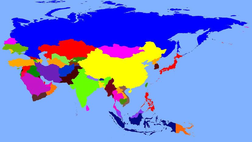
China's very long border enjoys 14 neighbors.
Advertisement
Ireland shares a border with Northern Ireland which is part of the UK.
Costa Rica is just north of Panama and both are under the US security umbrella.
The British, French and Russian Empires carved up the area they intended to take after defeating its current colonist, the Ottoman Empire, in World War One. Sykes-Picot is still cited as one of the main sources of trouble in the region today.
Advertisement
This library has doors on both sides of the border, so remember what door you came in if you don't want to be arrested!
Voltaire annoyed some of the wrong people with his speech so he had to be near a border.
Germany was divided by the Iron Curtain until 1989.
Advertisement
The Arctic only has a few nations that border it.
All of Poland's neighbors collapsed in that time, but Poland didn't.
There's a piece of India inside a piece of Bangladesh that is inside a piece of India... inside a piece of Bangladesh.
Advertisement
East Timor is one of the newest countries in the world.
Portugal and Spain divide the Iberian Peninsula.
China's land border is very wiggly, so it's the longest even though China is actually smaller than Russia.
Advertisement
It's Russia, of course, as it is the biggest nation.
The residents of Naco play volleyball over the fence.
Nebraska is really in the middle of the middle of the middle!
Advertisement
China doesn't use conventional time zones so this border gets awfully confusing.
Surveyors made a mistake so the western border is not entirely vertical on the map.
France and Holland share sovereignty of this little island.
Advertisement
Nazi Germany's invasion of Poland triggered World War Two.
India and Bangladesh have a singularly wiggly border that means it is incredibly long and complicated.
Sudan is directly south of Egypt, sharing the benefit of the Nile.
Advertisement
Lesotho is in the middle of South Africa.
Norway is one of the most northerly countries in Europe.
Gambia is surrounded by Senegal on all sides except the sea.
Advertisement
Togo is between Ghana and Benin.
The capital of Laos is Vientiane. It's one of the poorest countries in southeast Asia.
Brunei is on one of the larger islands that holds part ofIndonesia.
Advertisement
Chile and Argentina share one of the longest borders in South America.
The island of Hispaniola contains two sovereign nations.
Guatemala uses the US dollar and the local currency, the Quetzal.
Advertisement
Paraguay is not one of the three nations who meet at this point. You can put three limbs in three countries!